 Live Music Archive
 Librivox Free Audio
 Metropolitan Museum
 Cleveland Museum of Art
 Internet Arcade
 Console Living Room
 Books to Borrow
 Open Library
 TV News
 Understanding 9/11
tv Good Morning Washington at 600 ABC October 29, 2012 6:00am-7:00am EDT
6:00 am

"live, and in hd, you are watching "good morning washington," on your side. >> hurricane sandy and the impending super storm has hardware stores packed as people get ready for the impact. >> sandy is grounding thousands of flights and halting metrobus antwrens and local power companies are welcoming crews from all over the country. >> they are planning a response to the attack. >> we are bringing you live team coverage of the hurricane. we are live in ocean city, annapolis and we're in touch with the utility companies and governor martin o'malley of maryland. >> good morning. >> rise and shine and let's get the latest on the current conditions. >> good the rain is coming down and went to starting
6:01 am

to pick up a little bit. if you are just waking up, we have team coverage. sandy has intensified a little bit in the overnight hours. the maximum winds are 85 miles per hour and some additional strengthening as possible. the pressure has dropped and when that happens, we tend to see the wind speed increase. in addition, it will look up with the jet stream winds near the coast and it could intensify as it gets close to land fall. we think that will be late this evening for some time overnight. take look at-- it is easy to pick up where the center of circulation is. it is moving on a northerly track and now it is starting to pull north korean. the storm is expected to peak tonight and tomorrow morning and a flood risk will be of high concern that could last for several days. in addition to the floods, we are concerned about the wind.
6:02 am
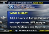
a high wind warning is in effect for the entire area. it could exceed 60 miles per these will be wind gusts, not sustained winds. went right now are 20 miles per hour. -- the winds now are 20 miles per hour. they will be at extreme levels for 24-36 hours so that is a long duration that we will be dealing with. we are expecting widespread power outages. we are also concerned about downed trees and not just because of the winds but also because there rain will be so heavy. the soil will be very saturated and that will loosen up tree roots. let's check in with adam caskey. >> it does not take much to
6:03 am

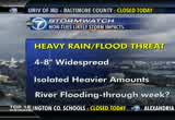
topple a few trees here and there. we're already seeing the saturation. there are areas of yellow and horns that indicate the heaviest rainfall which is over the day and western shore and moving into prince george's county. the rain will become heavier in and around the metro area and spread westward throughout the morning. the rain is falling at about two inches per hour. we have a flood watch in effect for the entire viewing area through tomorrow evening. there is some of the storm impact as far as the rainfall --
6:04 am

we probably will not see the surge from the drainage until later this week. it could have flooding impact around the metro area in the days to come, closer to thursday. another aspect to want to point out is the cold air behind us and that will give some heavy snowfall to parts of west virginia. in the highest elevations, they could see a couple of feet of snow. i'm fortunate, is -- it is the heavy, wet snow. -- unfortunately, it is the heavy, wet snow. it could linger into wednesday morning. we will have more updates coming up in a couple of minutes. >> thank you so much. light volume with all the clauses but the rate is intensifying. we have a lot of the rain coming down affecting rose parade little falls parkway is closed.
6:05 am

we also have a stretch of sligo creek closed. >> the good news is, not a lot of traffic out there this morning because people are staying home. >> we have caroline lucas from metro on the line this morning. all of metro is closed down at this point? >> that's right the decision was made early yesterday evening after we the weather forecast from the national weather service. that coincides with the closure of the federal government. the decision was made that we
6:06 am

would suspend service at least for today. >> we are hearing from all of our experts that tonight will be worse than last night. any idea as to when we might know about service for tomorrow? >> it is a situation where we will have to watch the forecast and see what damage we see across the system. there could be a lack of power on portions of the line to take into consideration and that will determine whether it is prudent to resume service. the underground stations and rail lines are all right but we still have the issue of power. we don't want a wind up with a situation or a train is stopped
6:07 am

underground. we will have to monitor the situation and see if the weather has calmed down. we will have a comprehensive track inspection and checked the stations and see what kind of outcomes we will get. we encourage everybody to still go to the metro website. >> there were also some public hearing scheduled for today and tomorrow and they have been cancelled? >> that's correct, we had planned for the safety of everyone involved to post bond. >> thank you so much. the worst of the storm will have to pass and then metro will be able to get the word out when the lines will back (at no service today on metro rails metro buses, or metro access.
6:08 am

much more on her can sandy coming up. we will go live for the eastern shore coming up. we will get more on what happens after the storm clears. >> sandy has affected both presidential candidates to change their campaign plans. >> you can see some waves crashing out there on the shore. things are starting to chalk up down in


6:11 am

the president's selection and both candidates are dealing with the impact of hurricane sandy. president obama is returning to the white house after an event in florida. he a plan to campaign in virginia and colorado and mitt romney is campaigning and canceled appearances over the weekend in virginia. this storm is really affecting everyone. >> let's check in with jacqui jeras and find out exactly how the storm will affect us. >> it will affect us in two big ways and that is the wind and the bloods. people want to know what kind of impact it could have on the election. also helena's on wednesday. -- also halloween is on wednesday. let's cross our fingers and the
6:12 am

kids are out of school today. you can stay home and stay safe. the storm has intensified and it is about 400 miles away from washington, d.c. we still have a long duration before this thing is out of here. it is just getting started at this time. we are expecting landfall and the worst impact to come in the overnight hours tonight into early tomorrow morning. it will hook up to the north and head toward the eastern great lakes and the canadian maritime. the winds of this morning had not been bad 10-50 miles per hour sustained winds. -- 10-15 miles per hour sustained winds. the gusts could be reaching 60- 70 miles per hour. it should taper off by noon tomorrow morning and the rain should taper of them as well. 30-40 mile per hour wind gusts
6:13 am

for the rest of the morning. 45-55 mile per hour wind gusts late today through the evening. let's talk about the rain we have had. it has been heavy in the delmarva peninsula. >> it is very heavy rainfall on the eastern shore. the rain will continue through tonight and into tomorrow. the heaviest rain will be late this morning from about 10:00 a.m. through 8:00 p.m. this evening. look at the rainfall totals -- there is a live look at the radar. it is from the east to the west.
6:14 am

you can see the area of yellow and orange indicating the heaviest rain on the western shore and eastern maryland pushing on to parts of the beltway. it is continuing to push westward. here is the predicted rain fall with this system. that is about 4-8 inches of rain across our region by the time this comes to an end. it will be closer to 5 inches around the beltway and closer to 9 inches on the eastern shore. >> thanks so much. the time is 6:14 and we will continue to keep you updated on sandy. this is a look at alexandria. you consider rain is really


6:17 am

>> this is a live look alexandria where the rate is picking up at this early hour. this is just the beginning of hurricane sandy moving into our area. >> let's check the conditions along the coast and we will start in virginia beach. we will see how the storm can be affecting folks down south. they still have power along the boardwalk in virginia beach. as we go to the outer banks there is a better look as to what is happening along the shoreline. we don't know about the tide of schedule. the surge has come in quite a bit from the last time we saw that picture. we don't know if that is the
6:18 am

tides or related to the surge. >> when you have a full moon, the tides are higher than average and you add in the onshore pushed and that makes it up. that is the concern but for us, for the most part, our winds will be offshore because we will get on the west side of the storm which means it will not be so bad in terms of surge. >> any advantage we can get. >> but we will get coastal flooding. wind and flood waters will be our greatest impact from the storm over all. it will be a long duration, 24 hours we have to go before things really pick up. it is a category one hurricane and will intensify as the central pressure has dropped and wind speed has increased. it is likely to intensify a little bit more as it gets closer to us right before
6:19 am

landfall as the transitions from an extra were posed tropical storm to a mid-latitude system. it does not behave like a normal tropical system once it has the interaction with the cold front. we will keep you up-to-date here. this storm is just beginning the rain has been coming down now for 12-24 hours and it will peak this evening and into tomorrow morning. we will watch for a steady increase throughout the day with winston watch for the rain to become have here this afternoon and the flood risk could last for several days, 4-8 inches will be expected. if you live east of '95 you have a better chance of flooding. here is the but the rainfall is at this hour --
6:20 am

there is a couple of inches as we head over to the coast. but it's not so bad out west. they could have some snowfall in west virginia before all is said and done we could reach 4-5 inches for much of the area and this is the cumulative rainfall between now and wednesday morning. somebody out there could be -- and 1 foot of rain. many people are asking how long the storm should last and it should affect us for wednesday and we will see the winds calmed down and the temperatures will stay steady. we had 80's a week ago and now we're looking at 50's all week
6:21 am

long. adam caskey will be back in a little bit with more on the rainfall and the predictions. >> thank you so much. sandy is taking a toll on the airlines. >> the new york stock exchange and nasdaq is closed. >> good morning the cost of hurricane sandy -- airlines are canceling thousands of flights throughout the northeast region. analysts say that will cost them hundreds of millions of dollars. the new york market will be closed today and even their online operations. it is the first closure for weather conditions in almost three decades. ubs make cut a third of its jobs in its banking division and possibly 10,000 jobs overall. the announcement could be made tomorrow. retail stores are taking aim at
6:22 am

the online competition this holiday season. they will have exquisite in- store deals to compete. "argo" made $12 million at the box of is this past weekend.


6:25 am

sports. the giants ended up winning the world series. they needed one extra inning to complete the sweep but i only needed four games to get the championship over the tigers. there was a leadoff single in the 10th inning and then they scored. the tigers could not answer and there is you're likely mvp miguel cabrera. it is there third world series title -- their second world series title in three years. back to coverage of hurricane sandy -- people living in flood-prone areas or warned there could be some problems. >> we now go to conditions in annapolis with john gonzalez. >> i can tell you that the rain
6:26 am

is only intensifying in annapolis. it is not only the rain but the wind as well with the gusts becoming more frequent in downtown annapolis. this is main street and we want to show you around. the businesses have tried to secure their areas as much as possible with sandbags and tarps on glass windows and doors. o'brien's is over here and they have trash cans in front to see if maybe the trash cans can help prevent water from the chesapeake to come into these businesses. you can see the run of already on main street. the drains are clogged with leaves. this is the time of year when you have a lot of leaves on the ground. we were just talking about how it does not feel like your average hurricane in the suburb. it feels like a northeaster. it is extremely windy but it is cold as well. we have the pierre and the
6:27 am

harbor with all the boats. the boats had been prepped for this weather but there really is so much they can do. you can see how hard that rain is coming down. this area is all too familiar with what happens with big storms. hurricane isabel was bad in annapolis for this entire area was under 5-6 feedwater and residents and merchants worry that this will be just as bad if not worse. >> thanks so much. 6:27 is the time and have another half hour of "good morning washington." >> power companies are watching and waiting so they can get to work. we will check in with a local power company and check in with brianne carter. things are [ mitt romney ] we have
6:28 am

to work on a collaborative basis. look, the reason i'm in this race is there are people that are really hurting today in this country. and we face this deficit -- could crush the future generations. and republicans and democrats boboth love america but we need to have leadership -- leadership in washington that will actually bringieople together and get the job done and could not care less if it's a republican or a democrat. i've done it before, i'll do it again. i'mitt romney, and i approve this message. teacher: this is west virginia pennsylvania, delaware. and this is maryland. every year marylanderspend five hundred and fifty million gaming at casinos in these other states. question seven will build a new casino and bring table games to baltimore... generating hundreds of millions for schools. and that money has to go
6:29 am

to education. it's the law. so vote for question seven. so we can stop spending all that money here, and keep maryryland money in classrooms like mine.
6:30 am

"live, and in hd, you are watching "good morning >> the rain band as moving a pause on the brain is pounding the shore in virginia beach. >> let's take a look at what is happening in our area. this is in alexandria this morning. it will be this way for at least the next day or so. it is monday, october 29.
6:31 am

>> thanks for started your week with us. we will check in with adam caskey to get the latest on the storm track. >> let's look at the graphics. here is the latest on hurricane sandy which is a good category one hurricane. it has sustained winds of 85 miles per hour so it has strengthened over night and early this morning. it is 420 miles east-southeast of washington. the strongest rainfall has come ashore on the eastern shore and the western shore of the bay and somewhat in the metro area. here is the storm scan and the estimated waved spikes. it is between us and bermuda. there are 40 foot swells over the atlantic. there were wave heights closer
6:32 am

to 20 feet closer to shore. in terms of rainfall, is moving east to west, coming from the eastern shore westward across the bay into the metro area. the heaviest area is around the beltway in this yellow and orange area. that indicates rainfall rates of about two inches per hour. overall, most of us will see about 4-8 inches of rain between now and tuesday evening. this indicates closed around 5 inches around the beltway by tuesday and around the eastern shore, it could reach up to 11 inches of rain. in southern maryland, a vacancy as much as 7 inches especially
6:33 am

in st. mary's county. here is my time line for the rest of the day -- steady winsds they will be increasing up to 35 miles per hour by noon and tonight, steady winds of 40 miles per hour and that is combined with saturated soil and could topple some trees. the winds will be ramping up throughout the day. it will peak later tonight while we are sleeping. the heaviest rainfall will most likely be from about 10:00 a.m. until 8:00 p.m. but it still will rain in spots tonight and tomorrow but the biggest downpours will be about 10:00 a.m. and that is combined with the wins and saturated soil and that adds to power outages and down trees. one aspect of the storm is the
6:34 am

blizzard warning in western maryland and west virginia in the higher elevations. the highest elevation could get up to 3 feet of snow. we will talk more about flooding coastal flooding, and have more updates on the storm. >> you mentioned the saturated soil and the potential for trees coming down, another reason to stay off of the rose. apple -- stay off of the roads. for metro, no service today. nov no vre or marc trains. it is quite intense out there and it will intensify with the hydroplaned potential in low- lying areas.
6:35 am

>> 6:35 so let's get back to coverage of hurricane sandy. >> let's check in with brianne carter out at ocean city, maryland. she has been there overnight and you have been keeping a close eye on the waves behind you? >> the water is starting to turn in ocean city. look at the waves behind me. part of the boardwalk is being covered in water. we had to move up beer onto a balcony because it was intense. we were on the boardwalk a few minutes ago when several waves several feet i came crashing over that sea wall and several feet of water rushed up against the hotel, flooding the stuff we had. we had to pack everything up and
6:36 am

move to higher ground and closer inland. that is the concern for people down here and that is why they don't want people coming down here today. they put this mandatory evacuation in place along the boardwalk. we saw a national guard crew drive down here in hummers and assess the situation. the rain has lessened slightly but the wind is still picking up and the power is still on. it was a very scary situation to have that water coming in so quickly, knowing how far to the south the heart of the storm remains. we expect to have more situations like this. we are trying to stay close. it will only get worse throughout the day. >> thanks so much.
6:37 am

it can be unpredictable 6:37 is the time. let's talk to the men in power. we understand predictions of the number of power outages can be dramatic. >> we don't know how many people will be affected but we know this system is so large that it has the potential for having significant impact throughout our service area beginning in northeast north carolina up into northern virginia and through the shenandoah valley. >> do you have any outages now? >> we have about 400 power -- customers without power primarily in the alexandria part of fairfax county. >> we have been communicating with our viewers and the overwhelming question people have is how long could they be without power? >> we say multiple days. it is premature at this point to say how many days we are talking
6:38 am

about but given the size of this storm and the fact that it will be over our system for at least 24-36 hours with some high winds and heavy rain that may hamper the crew's ability to get out on the spot to make repairs. we cannot predict exactly how long it will be but people should be prepared when the power does go out. it will be multiple days before we can get everybody back on >> lessons were learned with the derecho storm had over the summer. anything else we need to know? >> we learn something from every storm and every drill we do. we know we need to communicate better with our customers and we are working to do that. we have a mobile application now on our website dom.com where people can use their cell phones
6:39 am

to report outages. we always know there is more improvements we can make and we will be doing that. >> we appreciate it. the time the 6:39 and the temperature is 51 degrees on this monday morning. >> all the maryland beaches are taking a beating and still ahead, we'll tell with maryland governor martin o'malley about how the state is planning to respond. >> here are more live pictures


6:42 am

>> good morning, i am jacqui jeras with the latest on hurricane sandy. the storm has intensified overnight and the pressure has dropped and the wind speed has increased. it is about 400 miles away from washington d.c. and it is a category one hurricane. for the latest on the impact, we have a team coverage. we got adam caskey and chief meteorologist doug hill. >> not only did sandy intensify when we were slipping but there are indications it will intensify a little more as winds will get stronger. we are just on the very beginning of the direct impact of the storm.
6:43 am

it will intensify and become more dramatic as we go through tonight into tomorrow morning. high winds and the flood risk will be with us for several days. there is some heavy rainfall highlighted in yellow on the doppler radar. it is pretty much along the chesapeake bay of calvert county and st. mary's county. all this is pushing into the metro area now. another band is coming onshore in southern delaware. we are not the only ones experiencing the rain. rain is pushing into southwestern ontario in canada and this is a gigantic storm. computer models indicate it coming in between cape may and atlantic city. that will be later today. it is expected to make a turn to north-northwest.
6:44 am
the winds and rain will ramp up on the heaviest rain will be this afternoon and tonight. we will see sustained winds up to 60-70 miles per hour and higher gusts along the chesapeake bay. we are expecting flooding of four-8 inches near the chesapeake bay. we will have more for you in the next few minutes. >> thank you. 6:44 and 50 degrees outside. the entire dmv is bracing for the impact of the storm. >> coming up, we'


6:47 am

>> let's get right back to doug hill. >> let's look at our satellite picture. on the overnight in for red, it shows the low clouds. it looks like there was a break but this thing is firing up. it is offshore about 420 miles east-southeast of washington. there are warm sea surface temperatures. the center of circulation will be passing over cooler waters. it looks like it will come on shore later today into southern new jersey and maybe late tonight. exactly where to make landfall is not critical to our area. any area north of landfall will be where it has the worst surge which will be new york city and
6:48 am

new england. our issues will concern rain and wind. very heavy rain is sean -- shown on radar and that is advancing from east to west. there is generally 4-8 inches of rain in our forecast. by the time it tapers off, we will be closing in on 5 inches in many areas in the eastern shore will get considerably more than that. we are under flood watches across the entire region the high wind is not something we have experienced over a long period of time but it could be 24-36 hours of winds and wind gusts.
6:49 am

>> thanks so much. the impending super storm is expected to cause problems on the coast and inland. >> the maryland coast is taking a beating as of yesterday. governor martin o'malley joins us on the phone. we understand discovered brief to. >> i just received the morning briefing over the course of the night for the storm took the turn that so many predicted. it looks like it will be cutting across maryland. this is a monster storm. it sounds like it will last a long time and stress from our westernmost counties and take in the entire state and gaul all the way to trenton, new jersey. people need to stay indoors and hunkered down unless they have
6:50 am

already been evacuated from the lower coastal areas. we're in for a long and intense 24-36 hours. >> it is where we have a storm system that can cause the damage we're already starting to see. you've also got a blizzard warning out west. what are you going to do as far as additional safety emergency measures? >> we have already activated air national guard. they are already deployed with emergency operation centers in every county. we have dispatched a big contingent of state police to ocean city and they were helping in the evacuation. we have 23 shelters that are open across the state. before landfall, we have ordered closures that you rarely see us doing. the closure of the metro system
6:51 am

in the baltimore and washington areas, suspense and a bus service which is the last thing we suspend as well as the closure of the port of baltimore. we are fully activated and likely bring more national guard on board as the day progresses. >> governor martin o'malley, we thank you and lots of lessons learned about her hurricane irene and the derecho. that is being applied to the preparations for sandy. >> it very pro-active approach in advance of the storm which is rapidly approaching d.c. >> will have a live roundup of our headlines but first a look at your forecast.
6:52 am

[ minto ] you know, those ads saying mitt romney would ban all abortions and contraception seemed a bit extreme. so i looked into it. turns out, romney doesn't oppose contraception at all. in fact, he thinks abortion should be an option in cases of rape, incest, or to save a mother's life. this issue's important to me but i'm more concerned about the debt our children will be left wh. i voted for president obama last time but we just can't afford four more years. [ romney ] i'm mitt romney and i approve this message.

6:54 am

>> the time is 6:54. >> we have a live roundup of the headlines and we will go out to ocean city with brianne carter. >> conditions here in ocean city or already starting to deteriorate. this storm is still well to the south. behind me you can see the water already coming up to the sea wall. several times, it has come over the seawall. a state of emergency has already been declared. you can see the water coming over there. we understand there was a mandatory evacuation put in place last night.
6:55 am

we expect we will get an update from ocean city officials around 10:00 this morning. >> to the west of you in annapolis, we are definitely feeling the effect of sandy early this morning. the rain is intensifying and it has been running for several hours and the wind is picking up we want to show you the water. it is dark but the water is almost at street level at this hour. dozens of businesses have heeded the warning over the weekend and have boarded up their places and used sandbags, trying to prevent what happened here during hurricane isabel back in 2003. >> thanks so much. let's check in with adam caskey -- >> we have had some intensification overnight. it will increase slowly as it makes its way toward the coast
6:56 am

to watch for the winds to pick up today. the rain will intensify as well and we have already had over 1 inch on the eastern shore and that will increase. flooding is a concern and power outages are concerned. >> right now, we are just seeing the beginning. this is not just a quick hit. this will last 24-48 hours. the rainfall will probably be be heaviest at 10:00 a.m.-8:00 p.m. about >>
6:57 am

anncr: their ads, hopelessly untrue. west virginia casino launching the biggest ad barrage ever. don't be misled. the washingtonon post says
6:58 am

question seven is just... common sense. it'll create 4,000 permanent jobs. and stop maryland from losing millions to other states... every year. that's why business, labor, and teachers all support... question seven. and so does the washington post. vote for question seven. it's just common sense.

108 Views
IN COLLECTIONS
WJLA (ABC) Television Archive
  Television Archive News Search Service
Uploaded by TV Archive on
